
Building on Hollow Ground
Where is Hicks Branch Mine?
Hicks Branch Mine is an abandoned underground coal mine located off of Sawyer Pike near Vandergriff Road in Signal Mountain, Tennessee. Historic coal mining occurred here from at least the mid-20th century, likely leaving surface features and underground excavations.
In 2021, Urban Story Ventures purchased over 500 acres of land on Corral Road, originally rumored for development of a boutique hotel or golf course. Unfortunately it will be yet another generic GreenTech Homes subdivision. Engineering firm Ragan-Smith developed a plan for packing the initial 128 acres with 112 houses.
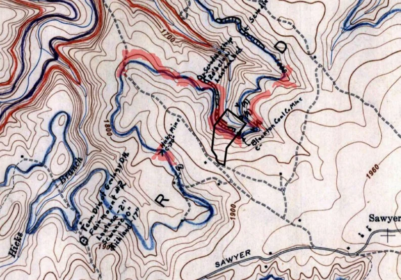
Multiple historical maps clearly show the Hicks Branch Mine and a nearby, unnamed mine.
Hamilton County staff requested Ragan-Smith “verify any existing mines”, but the engineer claimed that “surface mining was noted at one location on site… will not affect the proposed design.”
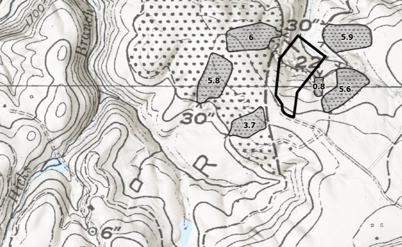
Historical Area Mining Details Maps
TN Geology & TVA Coal Resource Maps
TDEC Area Lidar Map & USGS
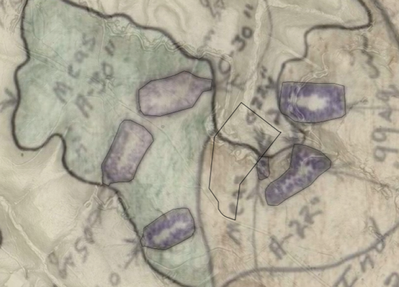
Mines & Subdivision Overlay
TDEC unsuccessfully attempted to contact the property owner to offer assistance “several times” in 2025.
An online Tennessee Division of Geology map shows “abandoned mine” outlines extending outward from the two mine portals which match the outlines on a handrawn TVA map provided by TDEC.
TDEC staff visited the site in mid-2025, and were able to locate both mine portals and stated it is “reasonable to assume that it does lead back into the underground mineworks.”
A 2023 Tennessee Department of Environment and Conservation (TDEC) Abandoned Mine Lands Section Report documented hazards from multiple abandoned mines present in the Vandergriff Road area:
open and partially open mine portals as large as 3.5ft x 5ft
portals which extend “dozens of feet” underground, with unknown stability
mine highwalls towering over 15ft with steep near-vertical drop-offs
evidence of water flow over highwalls raises further concerns about erosion and structural weakening
Take Action.
Take Action.

This image shows the August 2025 subdivision layout drawing overlayed onto the TVA mine map. It appears to show 13 houses over the dark outlines indicated to be “abandoned mines” on the TN Division of Geology map.
Before any construction proceeds, there must be a geotechnical assessment of the property — to ensure the safety of future residents and the protection of our community.
Speak up. Contact local officials.
Demand that this development be paused until any potential dangers are fully understood and addressed.
Contact Your County Commissioners:
district1@hamiltontn.gov, district2@hamiltontn.gov, district3@hamiltontn.gov, district4@hamiltontn.gov, district5@hamiltontn.gov, district6@hamiltontn.gov, district7@hamiltontn.gov, district8@hamiltontn.gov, district9@hamiltontn.gov, district10@hamiltontn.gov, district11@hamiltontn.gov